Before the Deposit: Why LandSentry Due Diligence Can Pay for Itself Many Times Over
Author
LandSentry Admin
Date Published

readTime: "9 min read" featured: true excerpt: "Before paying a land deposit, understand the hidden risks that can turn a dream purchase into an expensive mistake." coverImage: "/api/media/file/landsentry-due-diligence-before-the-deposit.jpg" tags:
- Due Diligence
- Land Buying
- Diaspora Buyers
- LandSentry
- ROI
- Property Risk
- Vacant Land Investing
- Real Estate Due Diligence
A LandSentry blog article for diaspora land buyers considering land purchases
A land purchase can look simple from overseas: find the listing, ask for the title, send the deposit, then start planning the dream home, farm, villa, retirement property or investment project.
But the most expensive land problems are often not in the listing.
They are in the:
- slope,
- drainage,
- access,
- boundary,
- road condition,
- flood exposure,
- utility distance,
- nearby development pattern,
- permitting path, and
- local ground conditions.
That is where LandSentry makes financial sense.
For a buyer in the United States, Canada or the UK, a land purchase often involves money at risk before the buyer fully understands the property.
A signed Agreement for Sale usually requires a deposit.
Public sources property guidance commonly describe a deposit of about 10% of the sale price, with additional transaction exposure from:
- legal fees,
- surveyor identification,
- valuation,
- travel,
- lodging,
- meals,
- transport, and
- time away from work.
LandSentry does not replace a lawyer, surveyor, valuer, engineer or government approval.
It helps buyers become smarter before they commit.
Its LIFT™ and CLEAR™ products are designed to screen land using:
- location,
- parcel,
- mapping,
- environmental,
- disaster,
- geologic,
- imagery,
- drone,
- boundary, and
- local-context evidence.
Core message: Before the deposit, buy information. After the deposit, you may be buying problems.
The prices used in this article
For this article, the LandSentry product prices are:
| Product | Price used |
|---|---|
| LIFT™ | US$375 |
| CLEAR™ | US$850 |
| CLEAR™ + Field/Drone Day | US$2,200 |
These prices are used for illustration.
Actual pricing may change based on:
- ground conditions,
- data provided,
- property size,
- location,
- urgency,
- required fieldwork,
- drone feasibility,
- survey/boundary complexity,
- access conditions,
- hazard exposure, and
- other aspects of the purchase.
The assumptions used for the ROI examples
These are estimates for illustration, not formal valuations or legal quotes.
Land prices vary widely by:
- parish,
- road access,
- views,
- zoning,
- development pressure,
- coastal proximity, and
- infrastructure.
| Cost item | 1-acre example | 5-acre example |
|---|---|---|
| Estimated land value | US$60,000 | US$175,000 |
| Deposit assumption | 10% | 10% |
| Estimated deposit at risk | US$6,000 | US$17,500 |
| Estimated legal-fee exposure | 2.5% | 2.5% |
| Estimated legal fees | US$1,500 | US$4,375 |
| Estimated surveyor/report cost | US$650 | US$1,200 |
| One US buyer visit: flight, lodging, meals, local transport | US$1,700 | US$1,700 |
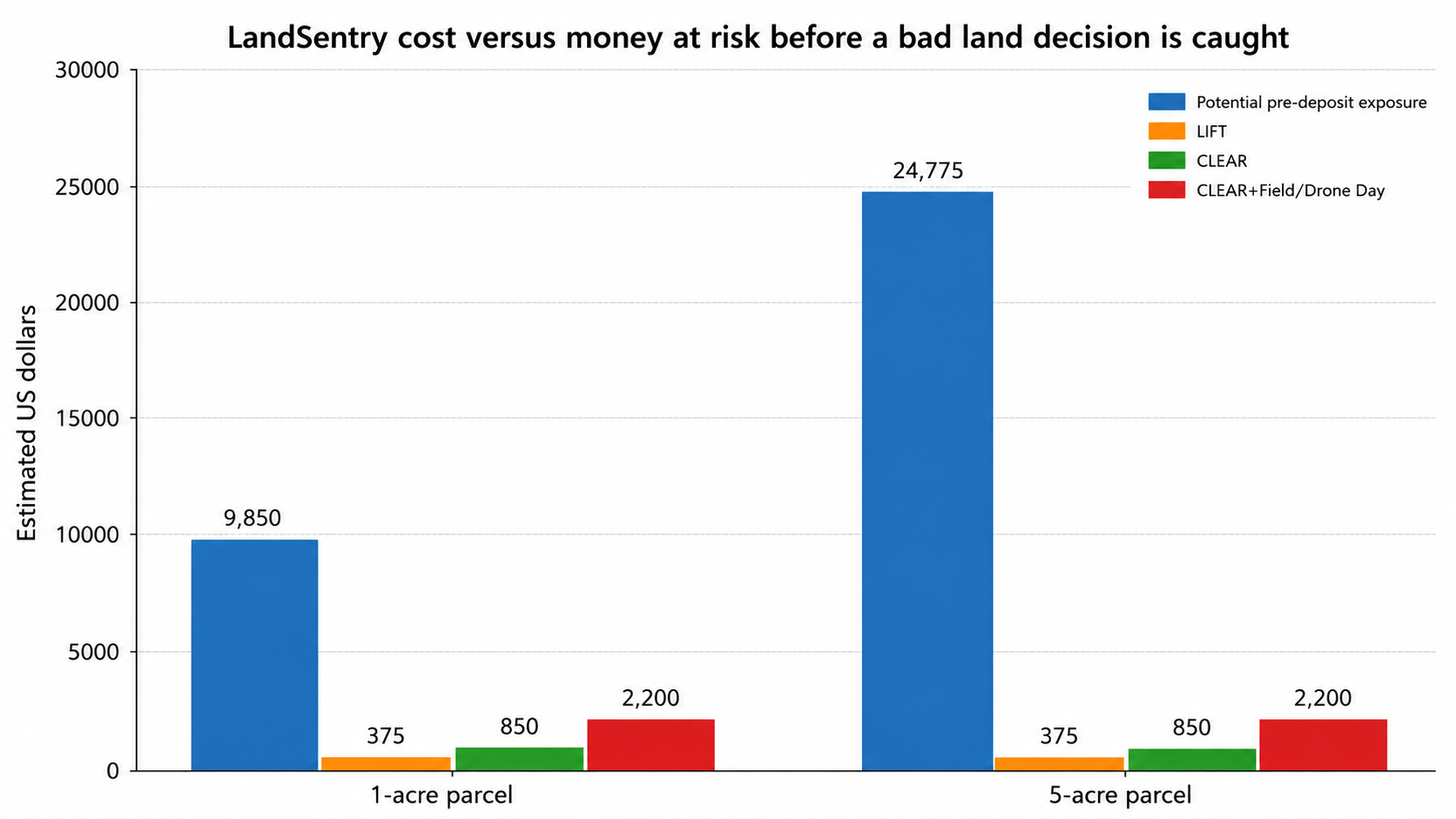
| Estimated money/time exposure before discovering a serious issue | US$9,850 | US$24,775 |
Example 1: A 1-acre parcel valued at US$60,000
A 1-acre parcel is often bought for:
- a retirement home,
- a small farm,
- a family compound,
- a rental cottage, or
- a future build.
The buyer may think the risk is manageable because the property is only one acre.
But one acre can still include:
- a bad access road,
- steep unusable sections,
- a gully,
- unclear boundary,
- flooding,
- landslide exposure,
- no practical utility connection, or
- a building pad that is too expensive to prepare.
Using the assumptions above, a 10% deposit is US$6,000.
Add:
- estimated legal-fee exposure of US$1,500,
- survey/report cost of US$650, and
- one buyer trip from the US at US$1,700,
and the buyer may have roughly US$9,850 exposed before discovering the wrong problem.
Cost comparison
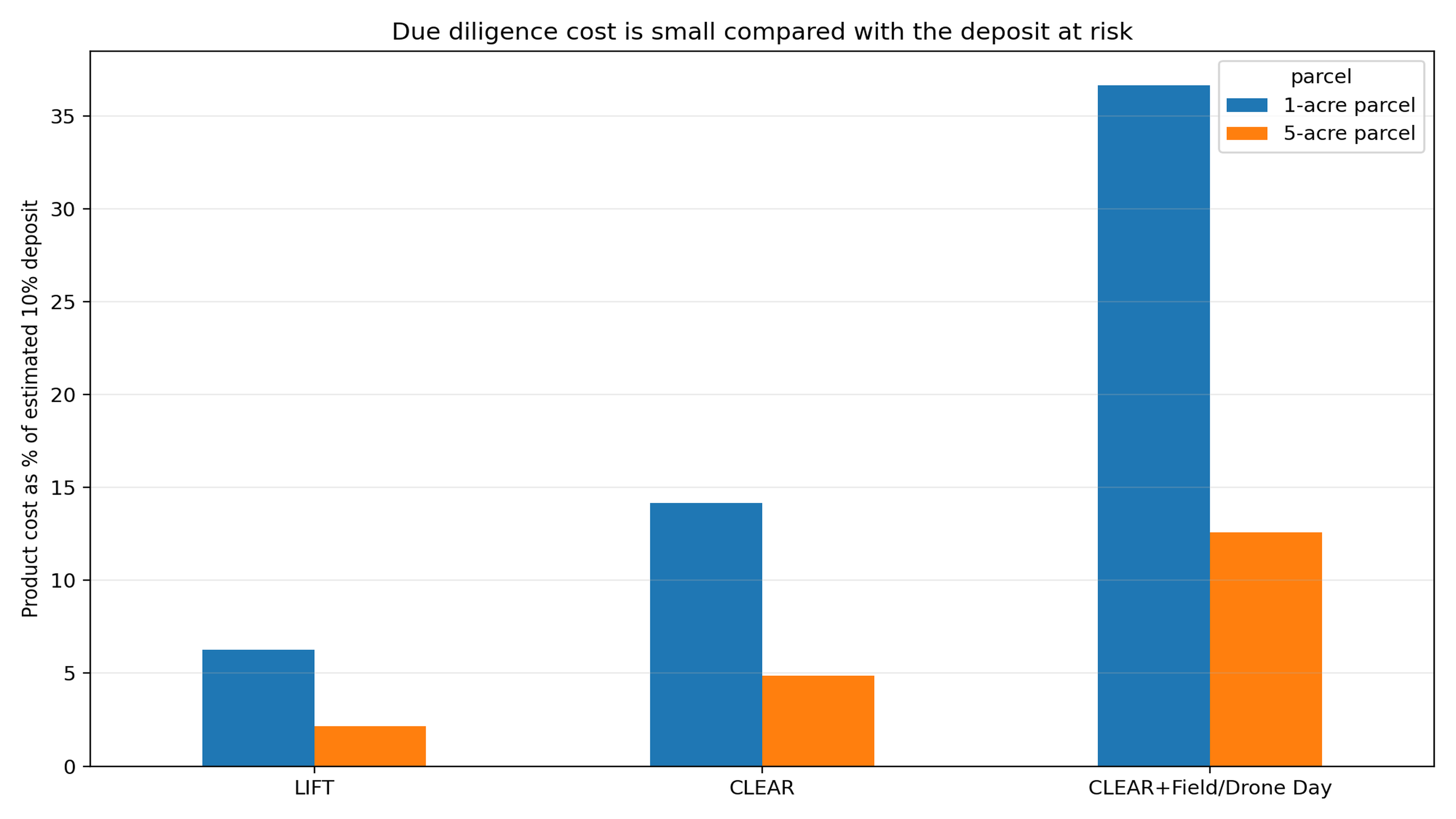
- LIFT™ at US$375 is about 6.25% of the estimated deposit and only 0.63% of the land value.
- CLEAR™ at US$850 is about 14.17% of the estimated deposit and 1.42% of the land value.
- CLEAR™ + Field/Drone Day at US$2,200 is about 36.67% of the estimated deposit and 3.67% of the land value.
If LIFT™ helps the buyer pause before sending a deposit because the land has severe access, slope, drainage, flood or boundary concerns, the avoided exposure could be far greater than the product cost.
If CLEAR™ or CLEAR™ + Field/Drone Day helps the buyer renegotiate, request seller conditions, require a surveyor or engineer before contract, or walk away from an unsuitable parcel, the value is not only financial.
It is also peace of mind.
Example 2: A 5-acre parcel valued at US$175,000
A 5-acre parcel has more upside — and more ways to hide risk.
It may be bought for:
- villas,
- subdivision,
- eco-tourism,
- farming,
- family retreat,
- retirement development, or
- long-term investment.
But five acres can include:
- multiple slope zones,
- drainage channels,
- variable access,
- unusable land,
- steep grades,
- poor road geometry,
- environmental constraints,
- unclear boundaries, or
- local permitting issues.
Using the assumptions above, the deposit is US$17,500.
Add:
- estimated legal-fee exposure of US$4,375,
- survey/report cost of US$1,200, and
- one US buyer visit at US$1,700,
and the buyer may have about US$24,775 exposed before discovering a serious problem.
Cost comparison
- LIFT™ at US$375 is only 2.14% of the estimated deposit and 0.21% of the purchase price.
- CLEAR™ at US$850 is only 4.86% of the estimated deposit and 0.49% of the purchase price.
- CLEAR™ + Field/Drone Day at US$2,200 is only 12.57% of the estimated deposit and 1.26% of the purchase price.
For a 5-acre purchase, LandSentry due diligence can be especially powerful because the property may have enough variation that the good part and the bad part are not obvious from a listing.
A seller may show the best view, best road approach or flattest corner, while the buyer later discovers that the usable building area is limited or that road access, drainage, slope or permitting will drive up costs.
What LandSentry may catch before the buyer commits
-
Access risk. A legal right of way may exist, but it may be too narrow, steep, washed out or unsuitable for construction vehicles.
-
Drainage risk. Water may cross the land during heavy rain, even if the property looks dry during a showing.
-
Slope risk. A parcel may be listed as 5 acres, but only 1 acre may be practical for building without expensive retaining walls, grading or engineering.
-
Flood exposure. A low area or gully-adjacent lot may flood or become isolated, even if the title is clean.
-
Boundary uncertainty. The location shown by a realtor, neighbor or seller may not match the title, survey or KMZ boundary.
-
Utility distance. Power, water or telecom may be farther away or more difficult to connect than expected.
-
Planning or permitting mismatch. The buyer’s intended use may trigger environmental, subdivision, hillside, access or parish planning issues.
-
Market overpricing. Comparable listings may show that the property is priced as if it is fully usable, even though access, slope or drainage reduce value.
The real ROI: avoiding one bad decision
The strongest return on investment is not that LandSentry replaces other professionals.
It is that LandSentry helps a buyer decide which professionals are needed, when they are needed and whether the property deserves deeper spending at all.
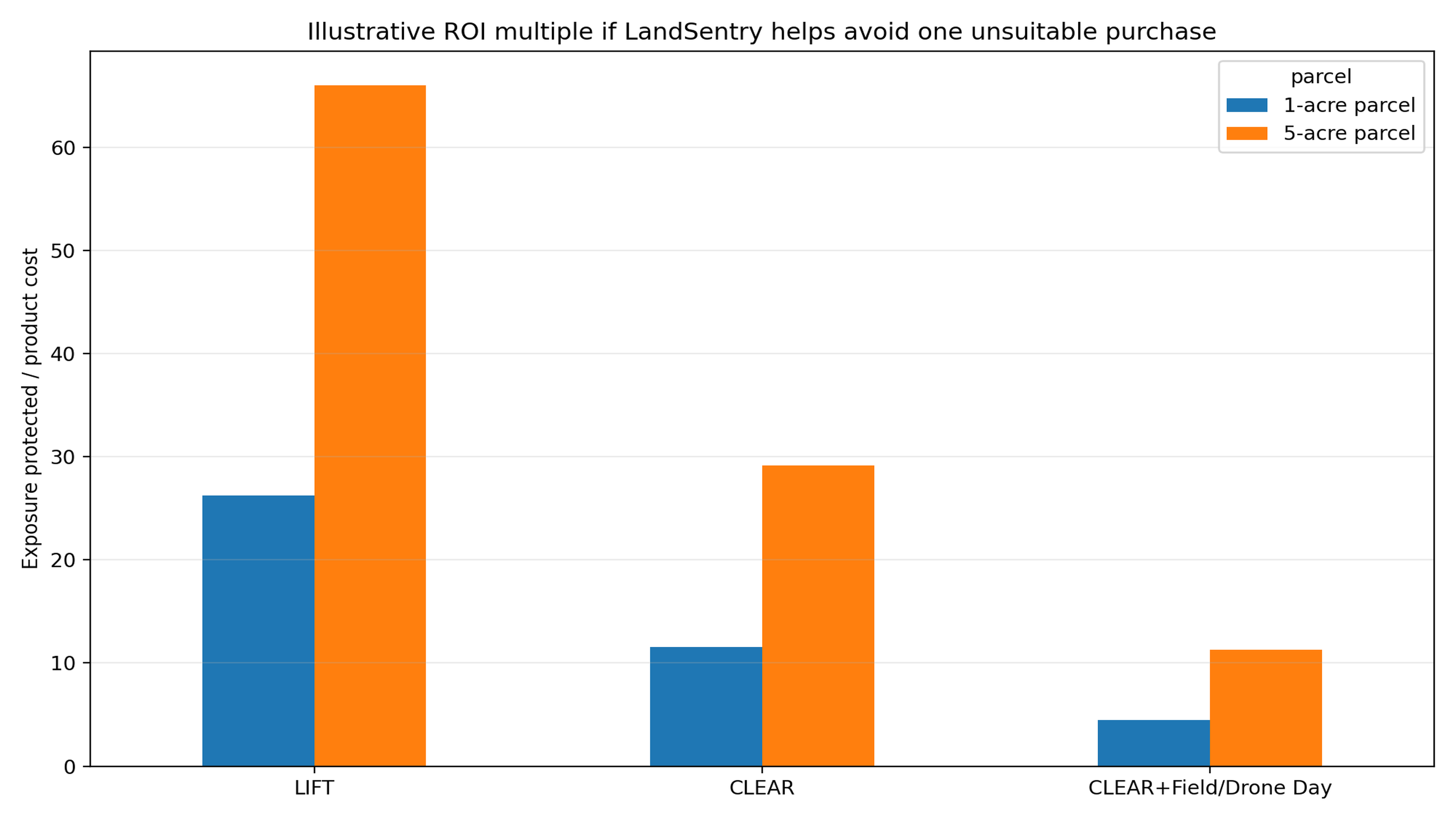
If LandSentry helps a buyer avoid a single unsuitable 1-acre purchase, the illustrative exposure protected could be US$9,850.
That is about:
- 26x the cost of LIFT™,
- 12x the cost of CLEAR™, and
- 4.5x the cost of CLEAR™ + Field/Drone Day.
For the 5-acre example, the illustrative exposure protected could be US$24,775.
That is about:
- 66x the cost of LIFT™,
- 29x the cost of CLEAR™, and
- 11x the cost of CLEAR™ + Field/Drone Day.
Those multiples do not include the larger hidden costs that can appear after purchase:
- retaining walls,
- new driveway design,
- drainage works,
- culverts,
- re-surveying,
- legal disputes,
- loss of rental income,
- delayed construction,
- family travel costs,
- insurance complications, or
- resale stigma.
Why peace of mind matters for diaspora buyers
Diaspora buyers often carry extra risk because they are buying from abroad.
They may depend on:
- a realtor video,
- family member visit,
- WhatsApp photos,
- Google Maps pin, or
- seller description.
These are useful, but incomplete.
A property can look attractive:
- in the dry season,
- during a sunny video, or
- from the best angle.
The most important risk may only appear:
- after rain,
- from a contour map,
- in a drainage path,
- in the access route, or
- in the mismatch between intended use and actual terrain.
LandSentry gives the buyer a structured, independent review before emotional and financial momentum takes over.
It helps answer:
- Is this land where the listing says it is?
- Is the access realistic?
- Is the land physically suitable for my intended use?
- Where are the slope, flood, drainage and hazard clues?
- Does the price reflect the risk?
- Should I proceed, renegotiate, pause or walk away?
- What should my lawyer, surveyor, engineer or local representative check next?
The bottom line
A land deposit can be thousands of dollars.
Legal, survey, travel and time costs add more.
LandSentry due diligence is small compared with the cost of discovering too late that the land is:
- steep,
- wet,
- inaccessible,
- mislocated,
- overpriced,
- poorly drained, or
- unsuitable for the buyer’s purpose.
For a 1-acre parcel, LIFT™ can be a low-cost first screen before a buyer risks a US$6,000 deposit.
For a 5-acre parcel, CLEAR™ or CLEAR™ + Field/Drone Day can be a rational investment before risking a US$17,500 deposit and deeper transaction costs.
Before the deposit, buy information. After the deposit, you may be buying problems.
Before you commit
Send LandSentry:
- the listing link,
- Google Maps pin,
- parish,
- acreage,
- intended use,
- title/survey documents if available, and
- any photos or videos you have.
Start with LIFT™ for a fast risk screen.
Use CLEAR™ when the decision needs deeper evidence.
Use CLEAR™ + Field/Drone Day when the land’s slope, access, drainage, boundary or development potential must be verified before you commit.